 |
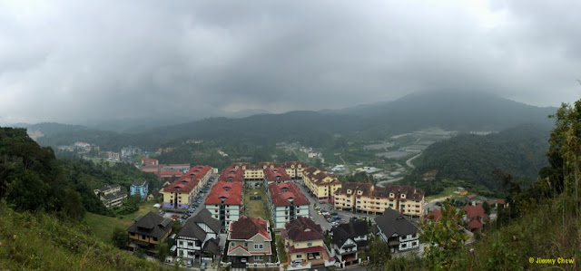
| Viewpoint just above Puncak Arabella in Tanah Rata. Mount Berembun is on the right and whereas Mount Batu Brinchang is right ahead (11 o'clock direction) obscured by clouds. |
Rhododendron Hill and Myrtle Hill were in my exploration plans since a few years back but never had the time to set foot on them. Until recently.
These two hills bear the old, colonial names during the days of late Sir William Cameron. Existingly, they are known as Bukit Mentigi and Bukit Kemunting respectively.
The name "Rhododendron Hill" was noted in a local paper dated 12th May 1925. J.B. Scrivenor (Director of Geological Survey, FMS) stated "Rhododendron Hill", "Myrtle Hill", "Parit Falls" and "Robinson Falls" had survived, further quoting the latter was name in honour of H.C. Robinson whereas the rest were descriptive and apt. Apparently the name Myrtle Hill did not survive; and the name Bukit Kemunting is seldom used.
On the larger map (10 in. = 1 mile), Scrivenor recognised that Myrtle Hill and Rhododendron Hill appeared as Bukit Kemunting and Bukit Mentigi respectively; he did not understood how "mentigi" appeared as a Malay name for Rhododendron; it was R.J. Wilkinson gave that Malay plant-name to represent rhododendron and whereas Kemunting was a literal translation. Mentigi in Bahasa Malaysia refers to a small plant.
Myrtle Hill (Bukit Kemunting) is located at coordinates N4.49129 E101.38444. The hill is located on the left side of the main road Jalan Pahang after the golf course but before reaching Brinchang town. It is the hill behind Parkland Apartment on its South-East with Strawberry Park Resort on its North-West. Jalan Kemunting is one of the roads branching off Jalan Pahang into Myrtle Hill. Since the hill is "well-developed" with private residences and resorts, I have not attempted to check out the hill. Moreover, there is no "tourist" forest trail to walk.
On the other hand, Rhododendron Hill, more widely known as Bukit Mentigi, has a peak with a viewpoint nearby and a couple of forest trails, namely Trail No. 13 and Trail No. 14.
Retracing the trails
Some quick facts:
- Trail 13 (moderate difficulty): "Start behind Cameronian Holiday Inn for a 1.5 hour walk with a stream that merges with Trail 14" (http://www.cameronhighlandsinfo.com/jungle_trekking)
- Trail 14: "A moderate trail leading up to Mount Mentigi (1,535 meters). Said to have great views. Start at from the Vetinarian Department in Tanah Rata, proceeding south to Mount Mentigi, eventually emerging on the at the 8km Tanah Rata road." (http://www.cameron-highland-destination.com/cameron-highlands-jungle-trail2.html).
- "The infamous development of Royal Lily destroyed trail no 13..." (http://www.malaysiakini.com/letters/205615)
I've decided to retrace T14 which is one of the trails least written about. T14 spans across Bukit Mentigi (Hutan Simpan Kekal Mentigi) North to South. Unlike most forest trails, the trailhead of T14 is mysterious as it is not visible from any road, and it resides inside the forest. To reach its trailhead on the North side, one needs to first traverse T13 whose entrance can be from either the back of Cameronian Holiday Inn or from the Veterinary Services Dept. T13 no longer exists as it is destroyed by the development (see 3rd bullet point above). It will definitely take a bit of challenge to locate T14 direct from the road. Given the knowledge about the destruction impacting T13, I did not attempt to spend time locating the trailhead basing on the signboards. I reached T14 and Rhododendron Hill peak via unorthodox hike (not disclosed herein -- "paiseh!")
 |
| Remnants of the meteorological observatory. The mast was believed to have been mounted with the anemometer. |
In the Malayan Saturday Post of 11th April 1925, one of the news photos showed Sir George Maxwell posed with the structure on Rhododendron Hill.
 |
| A number of this metal signboard are seen during my hike. In English: Permanent Reserved Forest. |
 |
| Monkey Cups (Nepenthes) can be easily seen on the slopes of Rhododendron Hill |
 |
| Upon reaching the peak, only the pillar and metal structure (not a trigonometrical station) remain. |
 |
| T14 has not been hiked for at least a couple of years, as evidenced by the massive spider webs blocking the trail. |
 |
| Trail is generally clear and nice to trek. |
 |
| Compared with signboards on most other trails, if not all of the rest, this one is painted white not yellow. |
 |
| Unnamed stream that flows from Dayang Endah (peak) and into Sg. Jasar which then flows into Sg. Bertam. |
Sungai Bertam tributaries include Sungai Burung, Sungai Ruil, Sungai Batu Pipih, Sungai Ulung, Sungai Jasar ,Sungai Boh, Sungai Habu, Sungai Ringlet and Sungai Manson." (http://www.cheammaychoo.com/environmental-problems/the-river-system-life-blood-of-cameron-highlands-part-1). Robinson Falls is located on Sg. Bertam (Trail No. 9), which takes about 30 minutes of hiking time to reach there. Speaking of Robinson Falls, this question was posed: "Who found 'the country above Robinson Falls'?" Per Scrivenor, it was not William Cameron, Leonard Wray or George Caulfeild; the Sakais called it Berembun ("dewey" mountain), and the first Europians to reach there were H.C. Robinson and C. Boden Kloss.
 |
| Markings perhaps demarcate the boundary for commercial development. Shortly after this is indeed the area cleared for development. |
 |
| Rhododendron Hill as seen from across, at the road leading up to Masjid Abu Bakar. Looks low but inside the forest is pristine! |
 |
| Trail 13 was left out in this map. It is the short trail that traverses
horizontally that joins with Trail 14 (source: http://www.cameronhighlandsinfo.com/jungle_trekking/). |
To comment, head over to original posting in FB: https://www.facebook.com/notes/jimmy-oddstuff/retracing-rhododendron-hill-peak-trail-no-14/10153085535476434